Google constantly handles enormous chunks of geographical data to improve apps like Maps and Waze, keeping them current with the state of roadworks in your alley. This information gathering also brings us stunning visuals with features like Immersive View and Street View. Over time, Google has collected enough data via satellite, aerial, and on-ground mapping to track the evolution of civilization and changes to the landscape in specific regions of the world. Two more years of the latest data has just been added to one such feature on Google Earth.
If you haven’t used the feature before, Timelapse on Google Earth is an interactive four-dimensional map of the world, tracking changes in topography and the spread of civilization since 1984. Until recently, only data until 2020 was available. Now Google is happy to announce two more years of extensive satellite imagery from 2021 and 2022 have been fused, so the timelapses you see are as current as they can be.
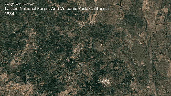
Impact of logging and wildfires on Lassen National Forest, California
Most of the satellite data used for Timelapse is gathered from NASA, the US Geological Survey’s Landsat program, and the ESA’s Sentinel satellites. Noteworthy locations to check out include the Egyptian deserts where irrigation systems have developed, California’s Lassen National Forest where wildfires caused destruction, and the gradual shift in meandering rivers of the Amazon rainforest in Peru.
You can take Timelapse for a spin, and see how your own locality changed in the last 40 years, but if you would rather just see the interesting locations, Google has curated a library of 800+ timelapses from 300+ locations worldwide. The content is hosted on YouTube, so it should be easy enough to watch in 2D and 3D. Google also allows downloading individual clips.