Read update
- Google makes it official
Google has been placing COVID-19 reminders, warnings, and information in many of its services for some time now. You can't use a Google service without being reminded to wear a mask, or of where to go for screening. It's even added various tips to Maps, including where to get takeout during the pandemic. With a possible new overlay feature, it looks like we might soon be able to add Google Maps to our list of COVID tracing apps.
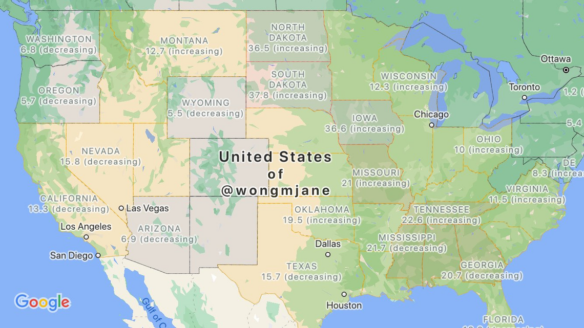
Jane Wong has shared screenshots she was able to trigger in Maps, showcasing the new feature. The pictures detail the COVID-19 tracking option alongside the other map overlays, like Traffic and Transit. The feature apparently sources data from Wikipedia, The New York Times, Johns Hopkins University, and Brihanmumbai Municipal Corporation. Using this information, the overlay colors impacted states, countries, and their borders. The map also displays whether the current numbers for each area are increasing or decreasing.
An overview of the prospective feature
International outbreak information by country
In the preview we've seen, it appears that the feature works internationally, with state-by-state info for the United States. If Google goes through with the release of the overlay, it'll be another in a long list of precautions provided by the company. If you're traveling out there, stay safe and be on the lookout for this feature.
UPDATE: 2020/09/23 11:39am PDT BY NATE FULLER
Google makes it official
The COVID-19 maps layer will be rolling out this week, according to Google. The layer will provide information for all countries and territories supported by Google Maps. State, county, and city information will be provided where available. Each area will be labeled, displaying how many cases have been reported per 100,000 residents, and whether that number is increasing or decreasing. Keep an eye out for the feature in the next few days.
Source: @wongmjane